Inarijärvi - Aanaarjävri – Sámi Sea
Inarijärvi is suitable for experienced paddlers. The nearest islands are suitable for short day trips, but longer trips require experience. Due to the large open water areas, the conditions in Inarijärvi may resemble sea conditions, and the large water area does not warm up to very high readings in the summer.
This article presents different route alternatives, with departure points including Inari village centre, Nanguniemi, Veskoniemi, Nellim, Partakko and Ivalo. Route descriptions have been prepared according to the departure harbour.
There are no marked paddling routes on the lake. These route descriptions show some indicative routes on the map. The maps in the article are not suitable for use on the terrain, but they help in planning the trip. Following the routes requires map and terrain reading skills and, of course, sufficiently favourable weather. The routes are not to be paddled in bad weather.
Connections
Roads circulate Lake Inarijärvi in all other directions except in the east. In fact, lack of roads on the east side of the lake is a key reason for the establishment of Vätsäri Wilderness Reserve.
When departing from Ivalo, there are two options: heading north or east. When heading north, the highway reaches Inarijärvi in the village of Inari, 40 kilometres from Ivalo.
You can reach Inarijärvi by water already from Ivalo. The boat can be launched in the centre of the village in Petsamontie 5. There is a boat slipway and a parking area on the shore of the river Ivalojoki.
By car
Inari from the North
- Lake Ukonjärvi can be reached on highway 4 (E75), driving 10km north of Ivalo. Lake Ukonjärvi is right next to the road, but there is no common slipway for the lake. The strait connecting lakes Ukonjärvi and Inarijärvi is located at the northeast end of Ukonjärvi off Hämähäkkiniemi.
- From the village of Inari, you can access the lake from the municipal harbour.
- Partakko is approximately 38 kilometres north of Inari on Sevettijärvi road No. 971, after which the road turns to Käyräniemi. Käyräniemi has a municipal boat slipway and a parking area.
- Lake Nitsijärvi is connected to Lake Inarijärvi. The distance to Nitsijärvi from Inari (road 971) is approximately 70 kilometres.
Inari from the East
- Departure from Nellim harbour: Drive 41km on road 969 east of Ivalo.
- Departure from Veskoniemi harbour: Drive about 9km on Nellimintie road No. 969, after which the road turns left to Veskoniemi. Follow this road for 14 kilometres. Before the village of Veskoniemi, you can also turn to the Nanguniemi harbour. The road is winding and hilly, and a map is necessary because the road forks to properties.
- Departure from Koppelo: The road turns to the right after the bridge from the northern side of Ivalo village. Follow the Koppelo road for approximately 11km, after which the road ends on the shore of the river. There is a boat slipway and parking area on the shore.
Starting points for excursions
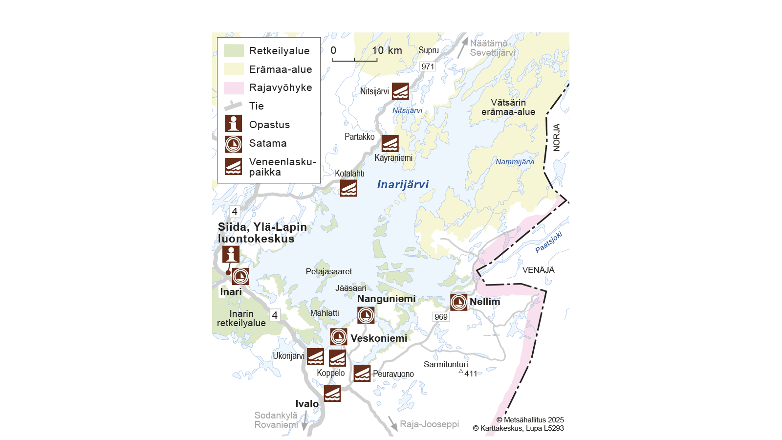
You can head to Lake Inarijärvi from many different starting points. As this is a large lake and not a river, there is no specific route, but you must plan the journeys yourself. Although a route plan has been prepared before departure, you must be prepared to change it according to the weather. The map below shows the most common starting points. They are boat harbours or boat slipways in public use.
Coordinates of Starting Points, WGS 84
- Ivalo lat: 68° 39.641', lon: 27° 32.632'
- Ukonjärvi lat: 68° 45.461', lon: 27° 27.565'
- Inari Holiday Village lat: 68° 54.138', lon: 27° 02.208'
- Inari village boat harbour lat: 68° 54.533', lon: 27° 01.155
- Kotalahti lat: 69° 04.984', lon: 27° 38.992'
- Käyräniemi lat: 69° 10.364', lon: 27° 54.620'
- Nitsijärvi lat: 69° 16.084', lon: 27° 58.771'
- Veskoniemen venesatama lat: 68° 47.141', lon: 27° 38.744
- Nanguniemen venesatama lat: 68° 49.700', lon: 27° 47.614
- Peuravuono lat: 68° 43.231', lon: 27° 45.272'
- Nellim boat harbour lat: 68° 50.896', lon: 28° 19.247'
Difficulty
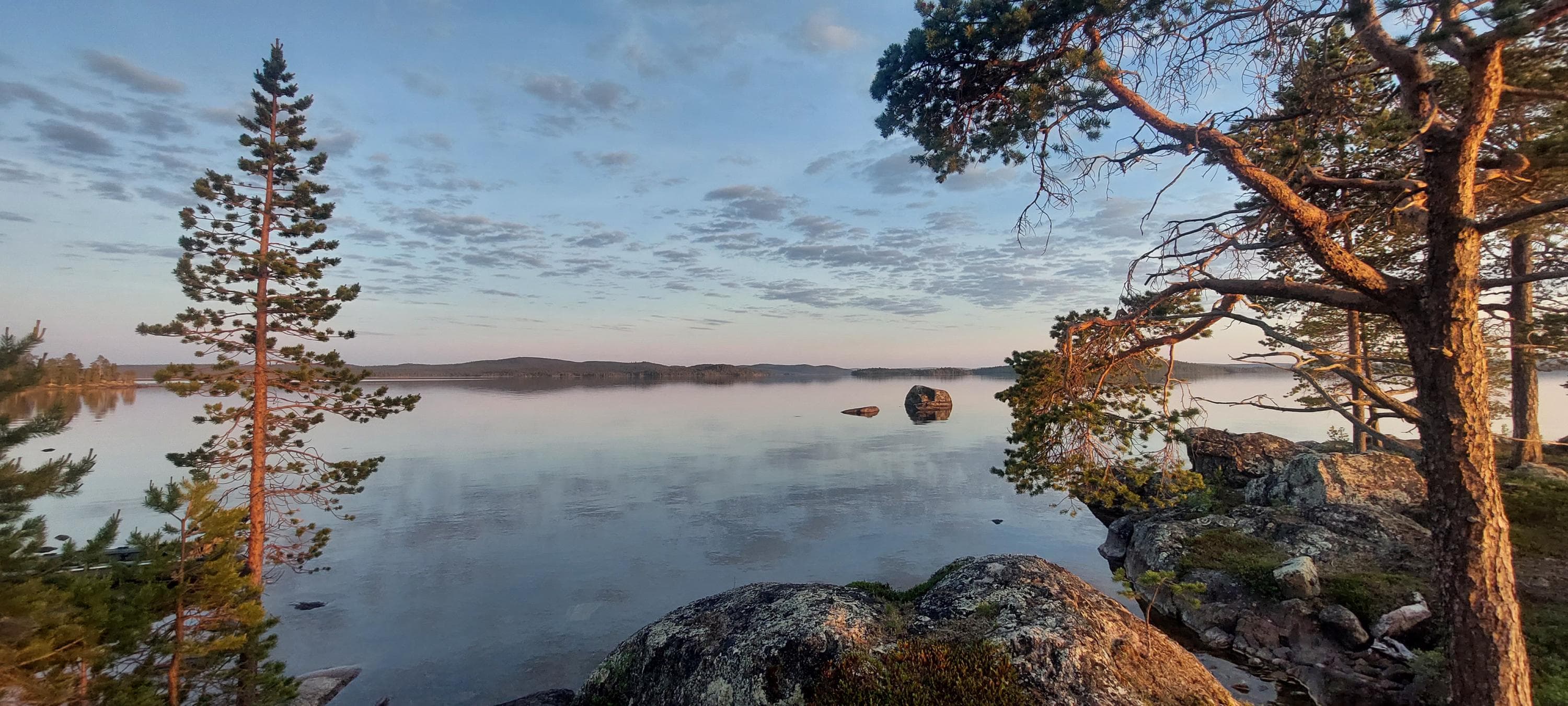
There are 3,318 islands in Lake Inarijärvi. The large number of islands and islets makes the lake very maze-like, attractive and also easy to get lost in. There is a huge amount of winding shoreline. Despite the large number of islands, the large lake also holds large open water areas. The largest of these areas are Kasariselkä, Sammakkoselkä, Vasikkaselkä, Satapetäjäselkä and Ukonselkä. The largest islands are Kaamassaari, Mahlatti and Leveä Petäjäsaari, which also have their own ponds.
Lake Inarijärvi has hundreds of kilometres of marked boat fairways. The fairways marked on the nautical chart are primarily intended for motorboats. The marked fairways are not suitable as such for paddlers who are seeking shelter of islands and who can move also in shallow and partly rocky coastal waters. However, they are very useful, as fairway marks help you determine your location.
Lake Inarijärvi should never be underestimated. Even if the lake is calm and pleasant at departure, the weather may change rapidly. On multi-day trips, you must also prepare for windy and rainy days. When it is windy, the waves of Inarijärvi may make the lake impossible to travel. In this case, the intermediate days are spent on the shelter of the islands.
In summer, there is daylight 24 hours a day. The sun does not set at all in June. Only at the end of July, will it go below the horizon for a couple of hours, and a short dark period at night begins in August.
The surface water temperature is highest at the end of July. In open water areas, it is approximately 14–15 degrees Celsius and in shallow bays even over 20 degrees. After mid-August, the water temperature starts to drop rapidly. Paddlers must be careful not to fall in the water when travelling on Lake Inarijärvi. Even though life jackets keep you on the surface, there is a risk of cold. It is always recommended to wear a dry suit due to the low water temperature.
Equipping for Lake Inarijärvi
The boating season begins in early June. Winds increase as autumn approaches, and the winds may last several days. The boating season ends at the latest in early October when the bays freeze over.
Wind direction in Inari is usually southwest or northeast. In the “nuora”, i.e. long narrows between the islands, the wind turns in the direction of the narrows. For example, Kaikunuora between Kaamassaari and Sarminiemi. For this reason, a person travelling in the water is usually experiencing either downwind or headwind.
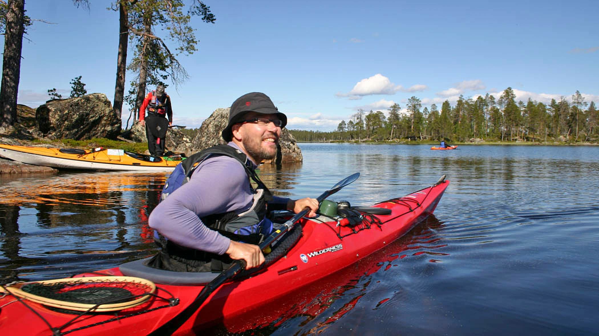
Local people move around the lake with motorboats, and recreational fishermen have boats equipped for trolling. Hikers usually bring their vehicles with them. In Lake Inarijärvi, a lake- or seaworthy kayak, for one or two people, with a rudder or a retractable skeg is recommended. An Indian canoe, or open canoe, is not very suitable for such open waters.
Metsähallitus has a fairly comprehensive network of boating bases for travellers in the lake. There are no shops, restaurants or other paid services on the islands of Lake Inarijärvi. This is why a person going to the lake must survive on their own. Wilderness skills, such as making campfires, preparing food on open fire or a camping stove, sleeping in a tent and navigation skills, are essential.
It is particularly important that matches and phone are kept in a waterproof case or bag stored in your pocket. Matches, phones, snacks and other gear are useless in the gear bag, if the gear escape with the kayak or the bag sinks into the bottom of the lake.
Warm and windproof clothing is absolutely essential, even if it feels like a T-shirt is enough on the day you start the trip. Sunglasses are needed to protect the eyes and sunscreen to protect the skin. Mosquito repellent is needed for mosquitoes and black flies. Mosquitoes are not a problem on the water, but on the shore, they can be a nuisance, especially at the turn of June and July. Mosquitoes thrive in calm weather, so it is a good idea to go to a place with some wind.
Read more about paddling gear, in finnish..
Read more about paddling safety instructions, in finnish.
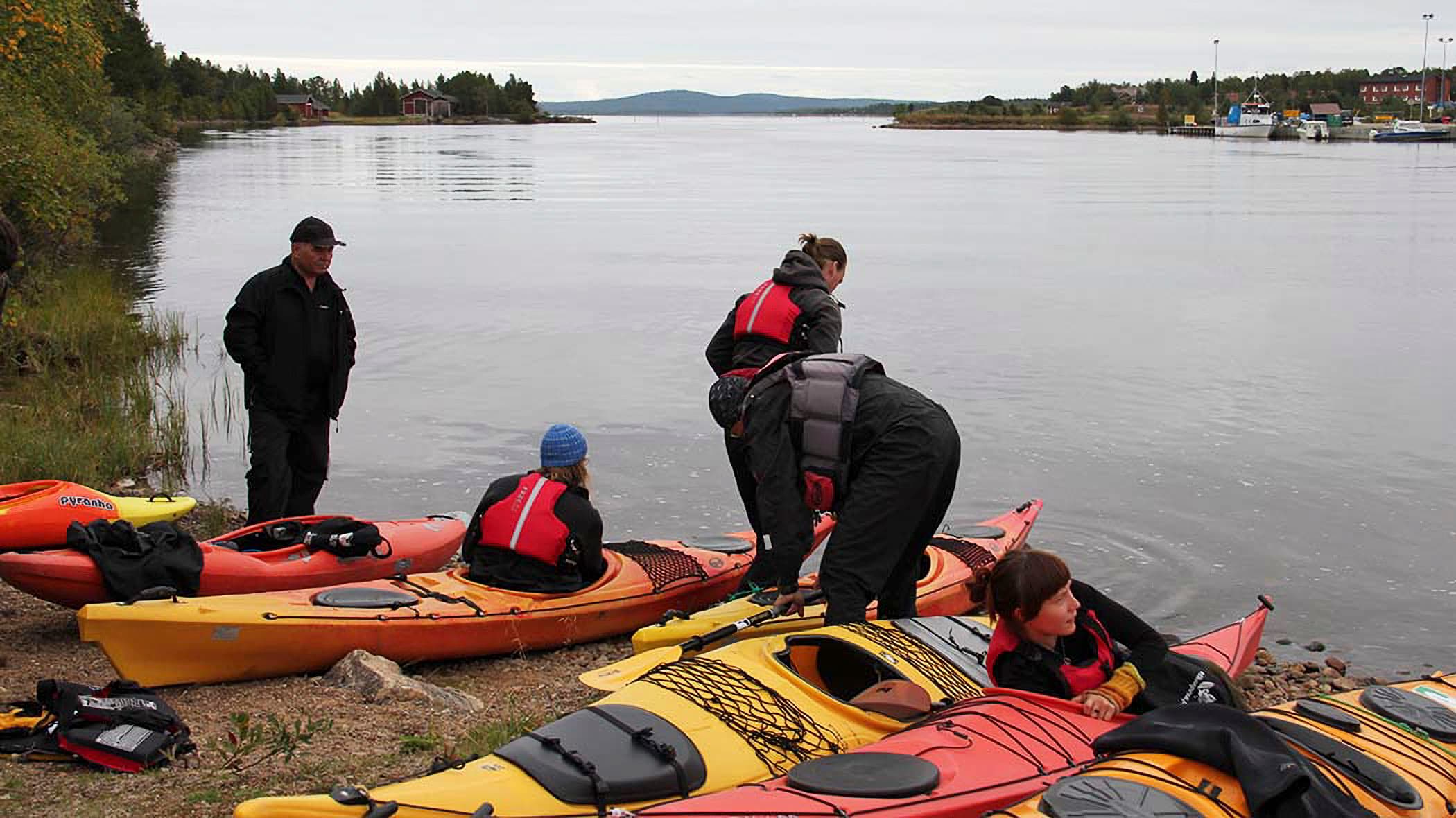
Inari Village Boat Harbour as Starting Point
Pahtaniemi Day Trip
The route is approximately six kilometres long, when paddling the downwind section straight and the headwind section along the shores. The route is quite exposed to winds.
From the top of Pahtaniemi’s steep rock, you can see far into Lake Inarijärvi. On the way back, the village centre of Inari is before you, and behind it the amazing Otsamotunturi fell.
There are no hiking structures in Pahtaniemi nor along the trail.
Ukko Trail
There are no accommodations along the trail, so a tent is necessary.
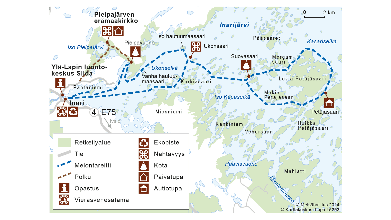
As soon as you leave the Inari harbour, you will face Juutuanvuono fjord. It is a fairly open water area, where eastern winds easily cause high waves. The islands offer little shelter. By paddling on the northern shore of the fjord, you will arrive at the first destination, To the Pielpajärvi wilderness church. The distance to the shelter is seven kilometres.
A marked trail starts from Pielpavuono fjord To the Pielpajärvi wilderness church. The bottom of the Pielpavuono fjord bay is suitable for overnight stays. Please note that the western side of the fjord starting from the bottom of the bay is private land.
From Pielpavuono fjord, the journey continues towards the two Hautuumaasaari cemetery islands. The first is the Vanha Hautuumaasaari (old cemetery island) located by Pielpaniemi. It is 3.5 kilometres away. The trail heads to eastern northeast towards the second Hautuumaasaari cemetery island, which is four kilometres away. The island is characterised by reddish beach sands and the darkness of the old-growth forest behind them.
Landing on the islands and walking there is allowed, but making fires, camping and collecting and digging funeral monuments are prohibited as is the case on other cemeteries.
There is only one kilometre of paddling from the cemetery island to Ukonsaari. The high rock island is visible from afar in all directions, and it has become one of the symbols of the municipality of Inari and Lake Inarijärvi.
While landing on the island is not prohibited by law, it should be avoided, as sacred places are traditionally not entered without a reason. Visitors to the island and its nearby areas must behave respectfully and appreciate its cultural significance.
Ukonsaari is the turning point of the trip. From there, you can return to the Inari boat harbour, and the return journey is 12 kilometres when measured in straight line.
Archipelago Trail
When continuing from Ukonsaari island to the east, the next stage is the Suovasaari boating base. It is 7 kilometres away, and the suggested route goes past several islands.
The distance to the Petäjäsaari boating base from Suovasaari is approximately 11 kilometres, when going around the Leveä Petäjäsaari island clockwise. The trail runs through the archipelago, which many find the most beautiful in Lake Inarijärvi.
The suggested route goes back to Suovasaari via the south, after 9 kilometres of paddling. When continuing south from there, it is advisable to select a coastal fairway marked on the nautical chart that runs south of Korkiasaari island. Through this route, the Inari boat harbour is about 17 kilometres away.
The entire suggested route is 60 kilometres long. It will take four days. With high winds, even five days.
Inari Village Centre – Partakko
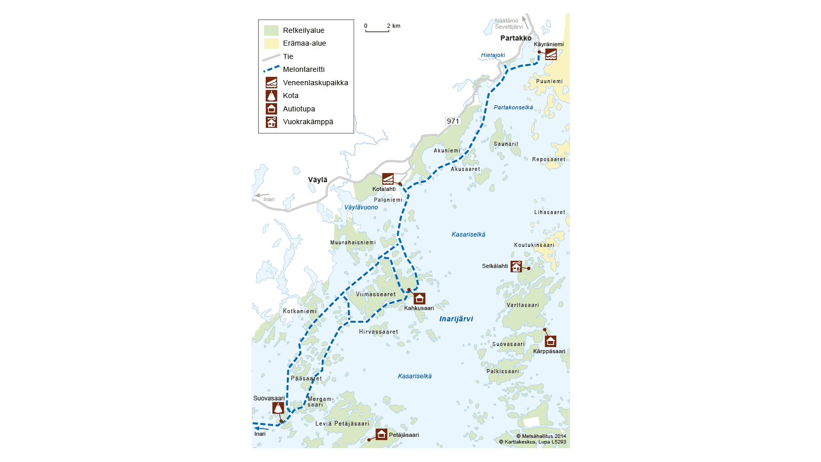
This suggested route goes all the way to Suovasaari like the Archipelago Trail. The length of the first day's leg will be 17 kilometres. This section is quite exposed to winds.
From Suovasaari, the trail continues northeast towards Kahkusaari boating base. The many islands protect against winds. Depending on the winds, Pääsaaret and Viimassaari islands are circled from the west or east. The length of the day trip is 16–20 kilometres depending on the route selection.
After Kahkusaari, you can head for Kotalahti and end the trip there. The distance to Kotalahti is only 9 kilometres. The longer option is to continue the journey to Partakko by following the northern shore of the lake. Please note that this section is quite open to winds from the south. You can complete the trip to Käyräniemi with a boat slipway. The length of the leg is 21 kilometres at its shortest.
The total length of the trip is approximately 50 kilometres. It will take at least three days.
Nanguniemi Boat Harbour as Starting Point
Open Waters Tour
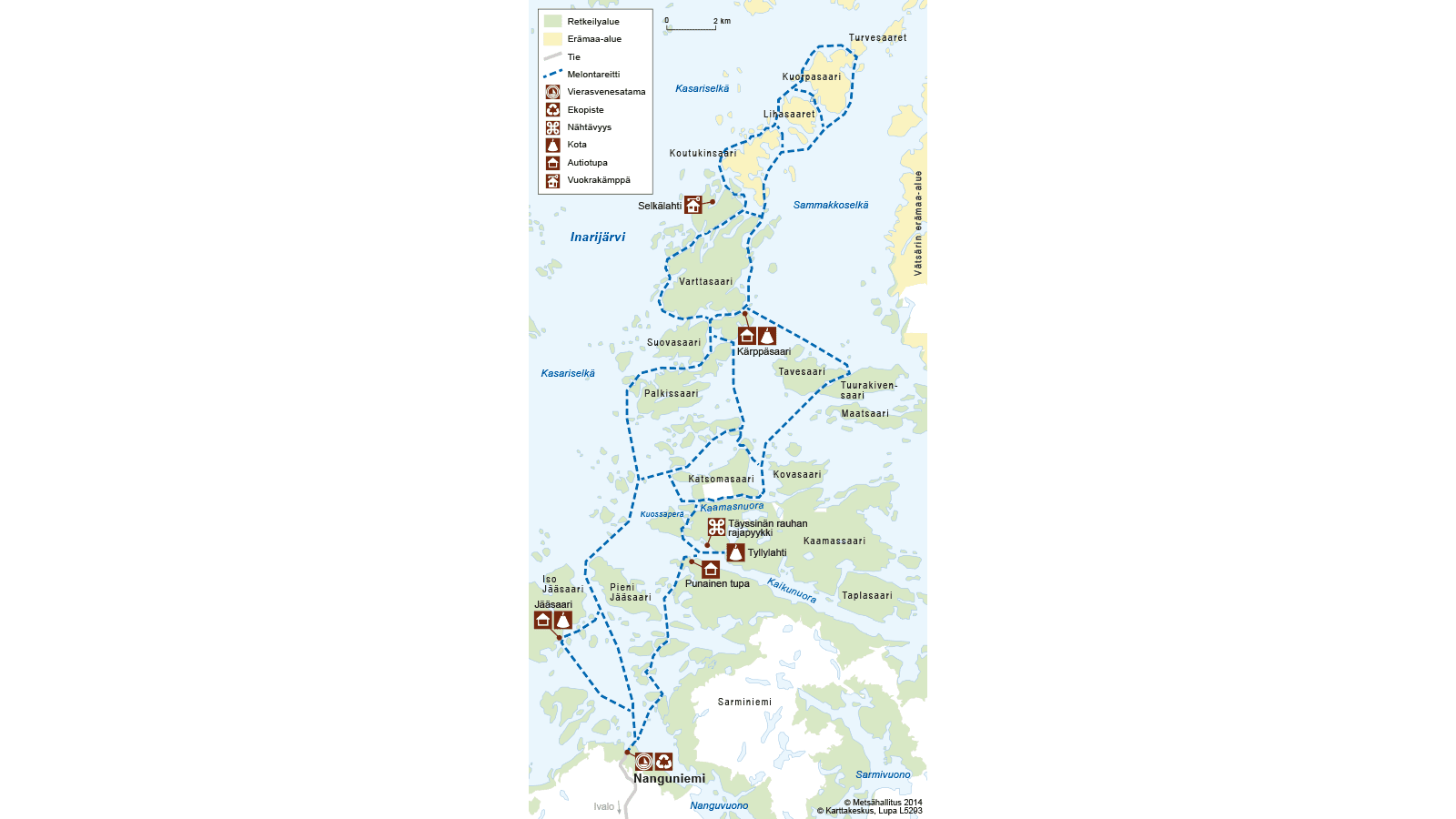
This suggested tour extends far to the central parts of Lake Inarijärvi and is therefore demanding but also rewarding. The week-long journey requires already considerable planning in terms of food. Although the lake water is drinkable, we recommend cooking natural waters.
Learn more about drinking water.
The weather may change a lot during the week, so you should be prepared. Warm and windproof clothing is a must, as is wearing headwear and gloves. The temperature may vary considerably, especially in early summer. It can be up to 25 degrees warm or chilling cold when the air masses come from the Arctic.
There are more than five kilometres to the first campsite at the Jääsaari boating base. From Jääsaari island the trail continues to Jääsaari strait. One of the busiest fairways in the lake passes through this strait, so paddlers should stay away from the centre fairway to avoid large stern waves of boats.
The islet in the centre of the Jääsaari strait’s mouth has a z-cairn. At this point, you must decide from which side you go around the long island chain in front, which separates Kasariselkä and Sammakkoselkä. The side of Kasariselkä is rocky and more open to winds than the east side of Sammakkoselkä. The boat fairway goes to Sammakkoselkä, where there are clearer waters. In windy weather, favour the middle option shown on the map. Paddling continues in the narrow straits protected by the islands to the Kärppätupa boating base. The distance from Jääsaari to Kärppätupa is at least 17 kilometres.
From Kärppäsaari, you can continue to the northeast, following the straits between the islands. There are plenty of sheltered natural harbours. The distance from Kärppäsaari island to the north of Kuorpasaari island and back to Kärppätupa is at least 27 kilometres.
You can return by paddling from Kärppätupa to the east southeast, north of Tavesaari island and heading from the strait between Tavesaari and Tuurakivensaari towards the bay between Kovasaari island and Keitinniemi on Katsomasaari island. From there, you can reach Kuossaperä along Kaamasnuora narrows and continue to Tyllylahti boating base or to Punainentupa. on the opposite shore of the narrows. Before that, you will go past the border mark for the Treaty of Teusina (year 1595). The border mark shows the ancient border between Sweden and Russia. The distance from Kärppätupa to Tyllylahti bay is 19 kilometres.
From Tyllylahti, the journey continues south and towards the port of departure. The rest of the journey is characterised by numerous islands. The minimum length of the winding trail is 10 kilometres.
The minimum length of the entire trip is 78 kilometres.
Nellim Boat Harbour as Starting Point
Nellim is a great place to start your paddling trip. Here are two different route options, a day trip and a three-day trip. On the longer trip, you must be prepared to spend the second night on your own, without built services.
Speinniemi Day Trip
The distance from the boat harbour to Speinniemi boating base is little over five kilometres.
The name of the boating base has been used with greater variability than usual.
You can return to Nellim either on the same route or by going around Lusmasaari island. Going around the island extends the return trip from five kilometres to 14 kilometres. The length of the day trip is thus either 10 or 19 kilometres.
Kaamassaari Tour
The trip becomes two days longer, when you continue from Speinniemi to the Tyllylahti boating base with a camping area. On the way, you should visit the WWII German prison camp north of Andreasnuora narrows. The prison camp buildings have already mainly decayed, but there is still something left of the camp.
The length of the first day's paddling will be 22 kilometres. In addition to Tyllylahti, you can stay opposite it in the Punainentupa, also known as Kaikunuora wilderness hut.
Narrow straits go around the Kaamassaari island. Keep your eyes open for a white-tailed eagle (Haliaeetus albicilla) in the sky, as there are regular observations of this bird on the lake. The trail continues to the strait between Kovasaari and Kaamassaari islands, after which Satapetäjäselkä open waters are in front of you. The wind direction should be noted, as the open water area should be rotated from the more sheltered side.
Return to Nellim either via Speinniemi or across Satapetäjäselkä to the southwest side of Tervasaari island and north of Lusmasaari. The distance from Tyllylahti to Nellim is about 30 kilometres.
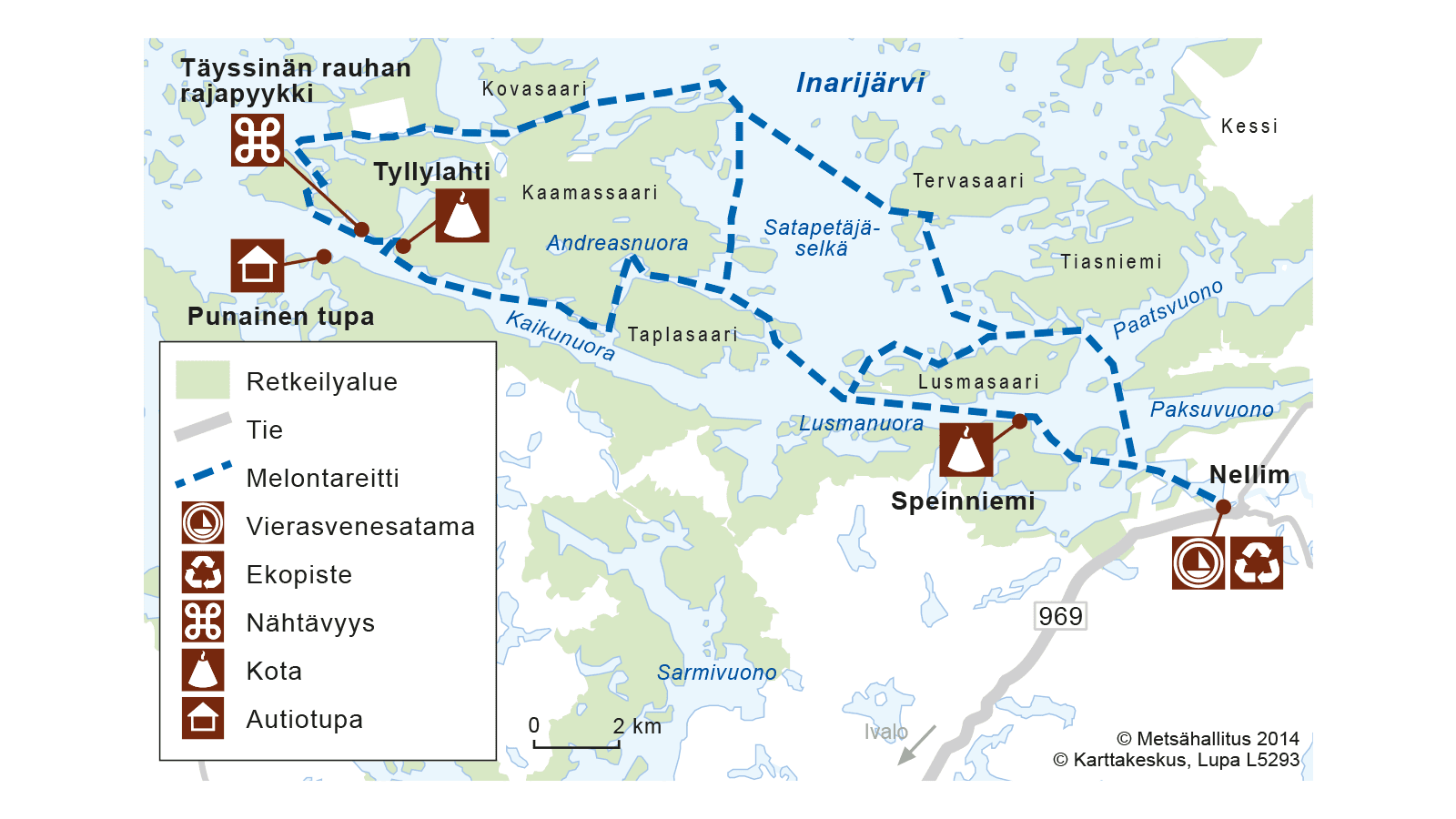
It is common that Inari Sámi place names have been “translated” into Finnish and changed their meaning at the same time. More rarely, several names are used for the same place. The original name of the peninsula adjacent to the boating base is "Speinnjárgâ". It originates from a Northern Norwegian man Spein Sarak, or Sarak Svendsen. In an old topographic map, the name has become Peiliniemi (Finnish for “mirror peninsula”), i.e. the meaning of the name is completely different (the mirror in North Sámi is speadjal and the peninsula is njárga). In some maps, the boating base is called "Lusmenyeri” (so-called Lusmanuora).
Partakko as Starting Point
Partakko–Nitsijärvi route
Possible starting point in Partakko is, for example, Käyräniemi boat launching site maintained by the municipality of Inari. The end point of the trip is the boat slipway in Nitsijärvi. Of course, you can do the trip the other way around. The distance between the starting point and the end point is approximately 14 kilometres along the road. You can pick up your own car from the starting point by bicycle, for example, if you take the bicycle to the end point in advance. As the suggested route is susceptible to high winds, in both Nitsijärvi and Inarijärvi, the trip requires paddlers to have the skills and experience to survive even in high waves.
The Partakko – Nitsijärvi route can be paddled in three different versions. The shortest route requires that the kayak is pulled or carried from Kallovuono fjord in Lake Inarijärvi to Lammaslahti bay in Lake Nitsijärvi. A 330-metre-long boat route has been built across the isthmus. There is no information on the current condition of the boat route. The length of the shortest option is 33 km. A suitable place to spend the night could be in Lammaslahti.
Another option is to continue past Lammaslahti to the Kuuva canal and use it as a shortcut to Koskivuono fjord. This means that you must paddle along the exposed northern side of Vasikkaselkä open water area. The shore only protects against north winds. The canal shortens the trip by 16 kilometres when travelling from Kanavavuono fjord to Koskivuono fjord. The total length of the trail is 42 kilometres.
The third and longest option goes around Pisterinniemi. The advantage of this option is that it has Pisteri boating base and its hiking structures along it. There is also an open wilderness hut at the boating base. It is 25 kilometres from Käyräniemi. The length of rest of the trip to Nitsijärvi and the side of the road is the same. There is a short Nitsikoski rapid between Lake Inarijärvi and Lake Nitsijärvi. It is easy to pass, as there are groynes and a walking bridge in the rapid.
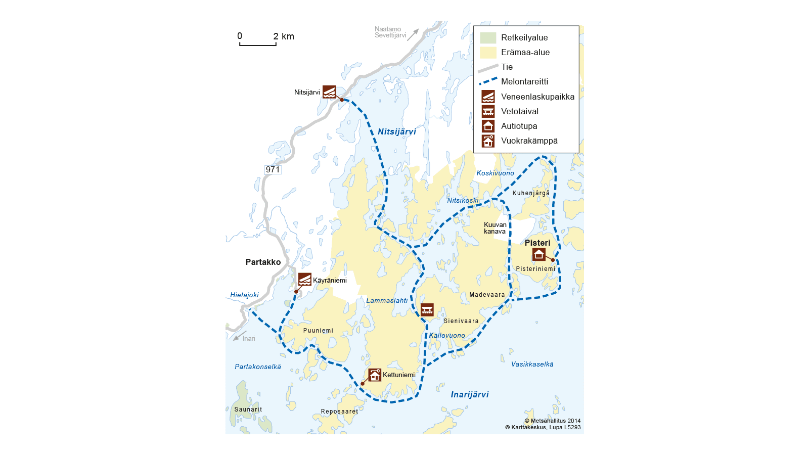
The name of the Kuuva canal comes from Matti Kuuva. A man by this name dug the canal with a shovel at the turn of the 1800s and the 1900s.
Veskoniemi Boat Harbour as Starting Point
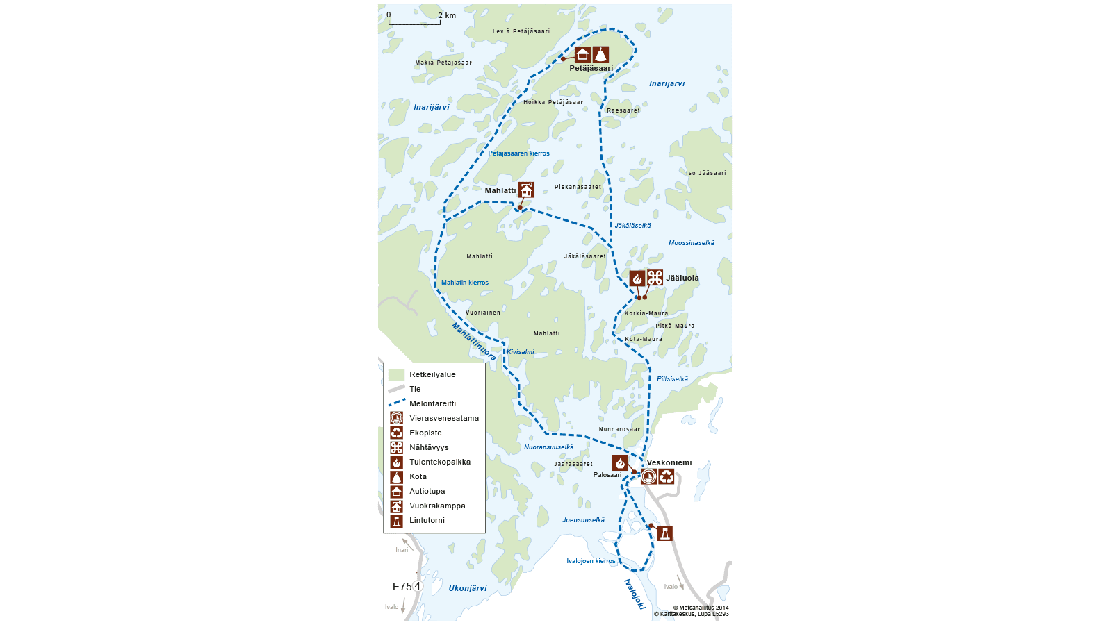
Ivalojoki River Estuary Day Trip, 10km
This trip is suitable for birdwatchers. The Ivalojoki estuary has a diverse waterfowl population. It can be admired from the Juurakkovuopaja birdwatching tower, which is located on the mainland. Birds are best seen and heard during the ice melting season in late May and early June. At that time, migratory birds heading north alongside local birds stop to rest in the estuary. When the nesting season begins in mid-June, the birds go quiet and hide. The length of the trip is approximately 10 kilometres.
Mahlatti Tour – Two Days
The length of this trip is approximately 30 kilometres, and it goes around Mahlatti, the largest island of Lake Inarijärvi. The suggested route is quite sheltered, thanks to the numerous islands. The landscape is barren and beautiful Inari landscape with rocky islands. The nature of the islands is almost pristine. Pine trees, in which the years have leaved their individual marks, dominate the vegetation.
There are plenty of sheltered natural harbours to enjoy breaks and stay the night. You need a tent for accommodation. There are several private cottages in the area, and it is not advisable to land near them.
The most well-known attraction is the Korkia-Maura ice cave. There is also a Metsähallitus pier, campfire site, firewood shed and dry toilet, in connection to it. There was a German prison camp in Mahlatti, during World War II. Its remains are still visible in Kivisalmi.
The views are attractive all the way. If you want to see further over the islands and you are fit, you can climb on Vuoriainen. The top of the forested hill rises 130 metres above the lake level.
Petäjäsaari Tour
The minimum length of the trip is 37 kilometres, but it can easily be extended when paddling between the islands. The trip takes at least two days. However, it is recommended to reserve three or more days to get to know the area properly. The suggested route runs through the charming archipelago of the southwestern part of the lake, where there are plenty of natural harbours. The trail is sheltered, but it also has sections where high waves are possible.
The trail can be travelled either clockwise or counterclockwise. When travelling clockwise, you can first head to the Korkia-Maura ice cave. The ice at the bottom of the cave does not melt even in the summer. The trail is mainly protected by islands, but Moossinaselkä open water area may be windy. The distance from the harbour to the ice cave is eight kilometres.
After the Maurasaari islands, the trail continues towards the strait between Hoikka and Leveä Petäjäsaari islands. First you must cross Jäkäläselkä open water area. Go around its numerous rocky islands from the sheltered side.
Most people head for the Petäjäsaari boating base. The shortest distance from the ice cave is 13 kilometres, and 21 kilometres from the departure harbour in Veskoniemi. The boating base is a great place to stay overnight.
The trail continues northeast along the strait, and then south towards Raesaari islands from the edge of the magnificent Kasariselkä open water area. Follow the shoreline and you will first meet Raesaari islands and then Piekanasaari islands. After Moossina, the departure harbour is already close. The distance from Petäjäsaari boating base back to the harbour is 16 kilometres.
Boat launching sites in the map service of the municipality of Inari, in finnish. (inari.karttatiimi.fi) . Select palvelut / liikennepalvelut / veneenlaskupaikka..
Inarijärvi boating bases and Open wilderness and rental huts.